


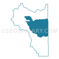
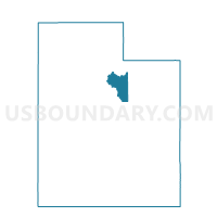
Wasatch County - East Voting District, Wasatch County, Utah
About
Outline

Summary
| Unique Area Identifier | 680372 |
| Name | Wasatch County - East Voting District |
| County | Wasatch County |
| State | Utah |
| Area (square miles) | 330.43 |
| Land Area (square miles) | 329.81 |
| Water Area (square miles) | 0.63 |
| % of Land Area | 99.81 |
| % of Water Area | 0.19 |
| Latitude of the Internal Point | 40.34194690 |
| Longtitude of the Internal Point | -111.08208510 |
Maps

Graphs
Select a template below for downloading or customizing gragh for Wasatch County - East Voting District, Wasatch County, Utah


Neighbors
Neighoring Voting District (by Name) Neighboring Voting District on the Map
- Fruitland Voting District, Duchesne County, UT
- Tabiona Voting District, Duchesne County, UT
- Wasatch County - Center Creek Voting District, Wasatch County, UT
- Wasatch County - North Voting District, Wasatch County, UT
- Wasatch County - South Voting District, Wasatch County, UT
- Wasatch County - Twin Creeks Voting District, Wasatch County, UT
Top 10 Neighboring County Subdivision (by Population) Neighboring County Subdivision on the Map
- Heber City East CCD, Wasatch County, UT (9,965)
- Duchesne CCD, Duchesne County, UT (3,839)
- Heber City South CCD, Wasatch County, UT (3,335)
- Uintah and Ouray CCD, Wasatch County, UT (11)